|
A Dutch, early 18th century, Captain's watch with Multiple
Tide table.
Signed:
G.J. Nauta, Leuwaerden
|
 |
By:
Kees Grimbergen
& Cees
Peeters. |
Table of contents:
Introduction.
More about the construction.
Tide
table.
Execution of the multiple tide table.
Konst der Stuerlieden. (Art of
navigation)
Operation
and use.
A typical complication.
Accuracy.
Afterthought.
Captain's watch?
Digital
assistent (PDA).
Notes.
Translated by W. A. van Klaveren.
 INTRODUCTION.
Recently (spring 2008) an unusual watch was discussed in the television
programme "Tussen Kunst & Kitsch" (the Dutch equivalent of The Antiques
Road Show). It concerned a golden²
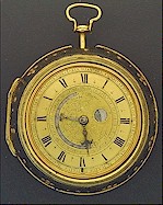
pocket watch, signed "G.J. Nauta, Leuwaerden", made c. 1720.
click here to enlarge
fig
1. Captain's Watch.
G.J. Nauta Leuwaerden, ca 1720.
Gijsbert (Gijsbartus) Jacobus Nauta is known as a ‘celebrated’
clockmaker who worked around 1720. According to Ottema (Lit. 8) he is
mentioned in deeds of sale from 1718 and 1725, in which he is the
purchaser of such property as houses on the Oranje-Eewal. He died in or
before 1757, as an advertisement in the Leeuwarder Courant of that year
concerns the sale of a "curious silver pocket watch, made by the late
Gijsbert J. Nauta". In 1946 Ottema saw a gold watch in a shagreen
leather case, signed G. J. Nauta, in the Fries Museum. According to him
it was a watch that showed the hour, the month, the date, the phases of
the moon and the tides in Dutch and foreign ports on the European
continent. It was thus a different watch than the specimen described in
this article. Longcase and table clocks by Nauta are also known.
(Morpurgo, Lit. 3)
The watch, described here in unrestored condition, is a relatively
simple one. It has a Roman chapter ring with half hour divisions (French
lilies) and quarter divisions. Along the outer edge of the chapter ring
the names of the months with the corresponding number of days are
indicated. Originally it had one hand, which probably had a 'tail'³.
click here to enlarge
fig
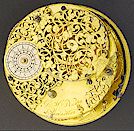
2. Back plate.
The verge watch has a duration of c. 27 hours. It has a balance with
balance spring and is from a constructional point of view simple. The
spring feet, pillars and balance bridge are beautifully shaped, pierced
and engraved, which was common practice in those days.

click here to enlarge
fig
3. Side view movement.

click here to enlarge
fig
4. G.J. Nauta's signature.
 MORE ABOUT THE CONSTRUCTION.
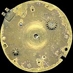
The movement is somewhat different from most watches of the same period.
The motion work is not driven from the centre, but via a 16-leaf pinion,
which is engaged with the great wheel (fusee arbor). For this reason the
usual centre arbor, running between the plates, is not used here.
click here to enlarge
fig 5. Front plate.
This 16-leaf pinion, which turns fully once every four hours, drives the
central part in the dial, which revolves fully in exactly twelve hours.
This unusual central part carries the hand³.
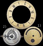
Engraved in it is a tide table, which indicates the times of high water
at nine different locations. It consists of two superimposed discs
turning around the same arbor. The two discs are the following, with
their characteristics described respectively:
1) A gilt brass disc with a semi
circular aperture; along this aperture from right to left the Arabic
numerals 6-12 and 1-6 are engraved. At one end of the aperture on the
left the word "Hoogh" (High) is engraved and at the other on the right
the word "Water". Opposite nine of the thirteen numerals a place name is
engraved. The numerals indicate the times of high water when the moon is
new (or full) at the corresponding locations. In addition the disc has a
moon phase aperture and on the outer rim a moon date ring 1-29½. (Figs
6, 7 and 10)
2) A silver moon disc with the phases
of the moon and a tide table with twice the division 1-12.
click here to enlarge
fig
6. Chapters
Both discs are toothed and engaged with each other via an 8-leaf pinion.
The silver moon disc and
2)
the probably originally tailed hand³
are fixed on the hour arbor (Figs 6 and 10).
This arbor is supported in the front plate and is driven via a
frictional connection with the hour wheel by the eccentrically placed
great wheel pinion.
 TIDE TABLE. TIDE TABLE.
The phenomenon of tides (high and low water) is related to the position
of the moon. The sun also plays a role but to a much lesser extent. The
sun has for instance a reinforcing effect when it finds itself on the
same side of the earth as the moon.
(spring tide and neap tide twice per lunar month).
Therefore a tide table is always put on a disc which also indicates the
phases of the moon and/or the day of the lunar month.
The moon revolves around the earth in 27.32 days, which during this
period (1/13 = 7.5%) runs a part of its orbit around the sun. It takes
therefore 29.53 days until the moon has the same phase (position
relative to the earth and sun).
On a moon disc of clocks and watches the month is approximated by 29½
days. Therefore after about two years and nine months an adjustment of
one day is required.
In this process the earth revolves once around it axis every day (in 23
hours and 56 minutes). If the motion of the moon in relation to the
earth is disregarded, then high water and low water occur twice a day
with a 12-hour period in between. (˜12.4 hours when this motion is not
disregarded)
The times of high and low water vary from day to day, so that after one
month a 24-hour cycle is completed. The tide tables consist therefore of
a scale of twice twelve hours, usually round the moon date ring(1-29½).
The only thing which is not yet established is the relative movement
(position) of both scales in relation to one another. This movement is
dependent on the place, for which the tides are given.
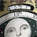
Amsterdam (Pampus) highwater, moonphase and age aperture on a 18th
century Dutch longcase clock.
(Source:
Bernard Meier)
For example, for Amsterdam (Pampus, the sand bank in front of the
Amsterdam port) it is high water at 3 o'clock when the moon is new or
full. For Harlingen high water occurs at 9 o'clock, when the moon is new
or full. Therefore, many tide table on clocks from Harlingen and
Leeuwarden have this indication.
End
A complication is caused by the closing off of the Zuyderzee, which put
an end to the tidal movement near Amsterdam and in the IJsselmeer (the
name of lake that was created). So for antique clocks and watches tide
tables from the 17th and 18th centuries should be consulted.

End
of this section, click
here to continue.

Notes:
2
Restaurations
to the case, and case-movement assembly points.
(Click
here to view case details)
3 To be discussed:
a) The use of the second hand, which was probably added later, is for
the moment unclear. See also Fig. 7.
The fixed angle with the probably original main hand is ≈9.5 lunar days.
Is it a coincidence that this is the difference between new moon and
neap tide or between half moon and spring tide? The main hand may
originally have had a 'tail' (Click here to
view hands)
b) The centre of the circular shaped aperture in
the gilt brass disc
1) shows signs of a
part now missing. (Click
here to view details)
c) For what other uses could this watch have been made??
Anyone who can supply information about the aspects mentioned above is
invited to share his knowledge with the editors.
(mail@antique-horology.org)
4
'Clockwise' or 'anti clockwise' on a
twelve-hour dial.
 back to text.
Literatuur:
Literature.
1) Schat-kamer ofte konst der
Stuurlieden",
compiled by Klaas the Vries.
Published "By Joannes van Keulen and Zoonen" 1777.
2) Gietermaker, C.H. 't Vergulde licht der zeevaart, ofte konst der
stuurluyden. Zijnde een volkomen and klare onderwijsinge der
navigatie, bestaende in 't geen een stuurman hoognoodig behoorde te
weten. 1677.
3) Morpurgo, E. Nederlandse klokken- and horlogemakers
vanaf 1300. Amsterdam 1970.
4) C.A. Davids. Zeewezen and wetenschap. De wetenschap and the
ontwikkeling van the navigatietechniek in Nederland tussen 1585 and
1815, De Bataafsche Leeuw, Amsterdam ISBN 9067071137
5)
Maritime Digital. Collection search
tool of the
Dutch Maritieme Museums.
7) Antiquarian Horology #3 vol.30 p.546-547
Acknowledgments:
- Courtesy Maritiem Museum Rotterdam.
www.maritiemmuseum.nl
- THF project webmaster: Fred Kats.
|
 Back to previous section.


 EXECUTION
OF THE MULTIPLE TIDE TABLE. EXECUTION
OF THE MULTIPLE TIDE TABLE.
The silver moon disc 2) is - like the hand³
- fixed to the hour hand arbor and therefore revolves fully once every
twelve hours.
The superimposed gilt disc 1) is not fixed
to the hour hand arbor but revolves around it. (see also
Fig. 10)
The silver tide table is visible
through the semi circular aperture in this gilt disc.
1)
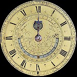
click here to enlarge
Fig. 7.
Noon in Ostende on the day when it is new moon.
The forecast of the high water times in other places can be read
simultaneously.
The second, probably later hand has been removed (simulation)
When the moon is new (or full) the hour numerals on the silver tide
table 2) correspond with the ones engraved
opposite the locations along the semi circular aperture.
(Fig. 7)
• Konst der Stuerlieden
(Art of Navigation).
To find out which locations are actually meant, two versions of the
"Kunst der Stuurlieden" can be consulted (Lit. 1 & 2):
the first "'t Vergulde Licht der Zeevaart" by Claas Hendriksz
Gietermaker dated 1677, the second "Schat-kamer ofte konst der
Stuurlieden" by Klaas the Vries dated 1777. They were published before
and after the Nauta watch was made.
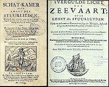
click here to enlarge
Fig. 8. Two manuals for navigating sailors. They were published before
and after the Nauta watch was made.
(Maritiem Museum Rotterdam)
Both books include a "Tafel" (table), in which 16 times of high water
are mentioned (every 45 minutes) and a number of "plaatsen and kusten"
(places and coasts) where these high tides occur.
(Fig. 9) In addition the times of high water for
al these locations on the days after a new or full moon are mentioned,
namely every day 48 minutes later (See also Fig.12).

click the pages below to enlarge
1777 1677
Page:
14-15
Page:
16
Page:
16-17
Page:
17
Page:
18-19
Page:
18
Page:
20-21
Page:
22-23
fig
9. 1777 en 1677 book tables.
In the table below, the high water data of the Nauta watch are compared
with the relevant data in the book tables.
|
Click here to
view the relevant North Sea map section. |
|
Watch
|
Harbour
|
High waters
as in book tables
|
1677
|
1777
|
|
6 |
Hamb |
6 uur 0 min. "Voor Breemen en Hamburg" |
|
● |
|
Bremen and
Hamburg |
6 ure 0 min.
"Voor Hamborgh" |
●
|
|
|
Hamburg |
|
7 |
Texel |
6 uur 45 min.
“In de gaten van Texel” |
|
● |
|
Texel |
|
6 uur 45 min.
“In de gaten van Texel” |
● |
|
|
Texel |
|
8 |
|
|
|
|
|
9 |
Vlis |
9 uur 0 min. “Voor het Vlie en het Amelander Gat” |
|
● |
|
Waterways
between Vlieland and Terschelling (to Harlingen and Amsterdam), and between
Terschelling and Ameland. |
|
9 uur 0 min. “Voor't Vlie" |
● |
|
|
Vliestream
(waterway to Harlingen) |
|
10 |
Calis |
9 uur 45 min.
o.a. “Voor Calais” |
|
● |
|
Calais |
|
11 |
|
|
|
|
|
12 |
Ostend |
12 uur 0 min. “Langs de kust van Vlaanderen” |
|
● |
|
Along the Flemish
coast |
|
altijdt 12 uren. "Aen alle Kusten van
Vlaenderen" |
● |
|
|
At all Flemish
coasts |
|
1
|
Vlissi |
1 uur 30 min.
“Tot Vlissingen” |
|
● |
|
Flushing |
|
12 uur 45 min.
“Tot Vlissingen” |
● |
|
|
Flushing |
|
2 |
|
|
|
|
|
3
|
Amst |
3 uur 0 min. Amsterdam (Pampus) |
● |
● |
|
Amsterdam
(Pampus) |
|
4 |
|
|
|
|
|
5 |
Dord |
5 uur 15 min.
“Voor Dordrecht” |
|
●
|
|
Dordrecht |
|
6 |
Antwerp
|
6 uur 0 min.
"Voor ter Goes en Antwerpen" |
|
●
|
|
Goes and Antwerp |
|
6 ure 0 min.
"Voor Antwerpen" |
● |
|
|
Antwerp |
|
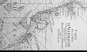
Click here to
enlarge
fig 9a.
A relevant North Sea map section.
The times indicated in the tables in the books are regional, as at the
time there were no time zones. The local times in Calais and Hamburg for
instance differ 32 minutes (8°). This and other factors cause the
difference between the times from the "time zone times"
(click
here) in present-day nautical almanacs.
The changes of waterways and shallows in the past centuries also
contribute to these differences.
 OPERATION
AND USE OPERATION
AND USE
It is clear that on this Dutch (Friesland) watch of nine locations the
time of high water is indicated simultaneously, varying from Calais to
Hamburg, in other words in the region of the Netherlands.
click here to enlarge
fig
10. Under-dial work.
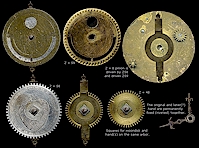
How the watch operates is quite simple. As the silver moon disc
2) which has 58 teeth, engages with the
same pinion as the superimposed moon date disc 1),
which has 59 teeth, the upper disc will lag behind at every 12-hour turn
by 1/59. (Fig. 10)
After two turns the hand³
will indicate the moon date a day later and the times of high water will
be indicated 24/29½ hour = ˜ 49 minutes later.
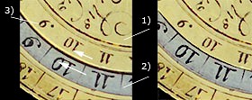
Fig. 11.
The upper disc with moon date 1) revolves
more slowly than the silver moon disc 2),
so that the reading of high water opposite the location will gradually
indicate later times.
3) Time of high water (9 o'clock) at this location (Vliestroom) when the
moon is new or full.
The months and the corresponding number of days, engraved along the
outer rim of the chapter ring, can serve as an aid when converting lunar
days to calendar days.
•
A typical complication.
For the tide table to work correctly, it is strictly speaking necessary
to set the hand on the right starting time when the moon is full or new,
in other words when the hour numerals on the scales correspond perfectly
(fig. 7) without turning the silver moon disc.
The maximum error that might occur owing to an incorrect setting of the
time, is six hours4,
which would result in a deviation of the tide table by ˜12 minutes (0.2
uur) (6/24 x 49 minutes).
This required resetting of the time is a typical complication of a
multiple time table.
The right time set varies from location to location, for instance 12
o'clock for Ostende (Fig. 7) or 3 o'clock for
Amsterdam etc. This 'norm location' could be called the 'home port' in
this context.
For setting purposes there is an angle of 45° between the two "squares"
on the hour hand arbor, to which the hand and the silver moon disc are
attached. (Fig. 10) In this way the hand can be set in eight positions
(times) which differ by 1.5 hours. This cannot really be done without
the help of a qualified clockmaker.
Setting the watch for stationary use in one particular location is in
fact feasible. For mobile use (onboard), however, it would be necessary
to set the watch according to the local time of the 'home port' to
maintain a correct time table.
•
Accuracy.
The scales which turn gradually (constantly) in relation to each other
provide a correct reading of the phases and age of the moon at any
moment.

Moonphase aperture (waxing crescent).
(click
here for more on moonphases)
However, for predicting the next time of high water,
this time must be shown by a jumping action comparable to calendar
indication mechanisms in clocks, and is to remain fixed during a set period of
time. Therefore, on this permanently turning scale, which does not jump,
the reading is correct only once per period between two
"high waters".
Because of this 'imperfection' this repeating error is largest shortly
after the previous time of high water, viz. ≈25 minutes (0.4 hours) on
average too early. The times of high water established when the moon is
new (such as 12 o'clock for Ostend, 3 o'clock for Amsterdam etc.) have
an error of ≈1 hour, so +0.5 and -0.5 hours. The accumulated error can
therefore be ≈0.9 hours (0.5+0.4).
 AFTERTHOUGHT. AFTERTHOUGHT.
•
Captain's watch?
Whether this pocket watch in this case could be worn on deck at rough
seas with lots of "spray" is doubtful. After all, it is not a waterproof
"Omega Seamaster". A dry spot in the captain's cabin seems to be a
minimum condition for longer use. The movement does not show traces of
excessive corrosion as a result of wet conditions.
(Click
here to view case details)
As not only the tides do cause high and low waters but also the
direction of the current and its strength, accurate tidal data are
extremely important for safe and successful navigation at sea.
The doubtful seaworthiness and possible inaccuracy of ≈0.9 hours,
perhaps justifies the question of whether this watch was not mainly used
on land (by a ship owner or a trader?) to be able to estimate the times
of arrival and departure of a ship in various ports (?). Moreover it was
for example important for the market price of fish to know whether the
fishermen were be able to go out fishing once or twice a day. (Lit.7)

click here to enlarge
Fig. 12.
"to find the time of high water,
on the basis of the age of the moon."
It is likely that the captain or the mate himself calculated the times
of high water with the 'Konst Der Stuurlieden' (Fig. 12),
or used the tables in this book. His data on currents and tides of the
Dutch waters, improved by his own observations were possibly also
onboard?
• Digital assistant. (PDA)
Interesting about this "Captain's or Ship owner's watch" is that Jacobus
Nauta made it possible to read the times of high water at nine different
locations in the Dutch waters at the same time with a very simple
construction.
In this way a number of data in "Konst der Stuurlieden" was directly
available to the user; something that in this age is realised by a
Digital Assistant. This watch shows that this was done mechanically
almost 300 years ago.
November 2007, The Horological Foundation.
This page is subject to ongoing
revisions.

|


